Collection Search
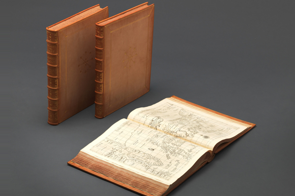
On the Mystery of the Sea, a Sea Atlas by Sir Robert Dudley
- Nationality Italy
- Quantity 3
- Era 1646
- Exhibition Place -
- Material paper, leather
- Size(cm) 47.7×56.0×7.6
A sea atlas (or maritime atlas) or nautical chart is a guide for ships to safely and accurately navigate the seas.
Sea atlases and charts relate many details essential to marine navigation, such as ocean depths, seabed features, shapes of islands, navigational hazards and obstacles, characteristics of ocean currents or tides, coastal topography, and locations of aids like lighthouses and buoys.
With the introduction of the Travels of Marco Polo to the Western world, production of nautical charts gained momentum, and the first type produced was known as a portolano or portolan chart. Dating back to 13th century Italy, a portolan chart is characterized by straight rhumblines or windrose lines emanating from the centers of compass roses depicted on the map.
These lines of bearing enabled mariners to more easily discern the directions required to navigate from one port to another.
Portolan charts were widely used until the 17th century, when modern nautical charts using the Mercator projection were first developed.
Currently, the earliest surviving portlolan chart is the Carte Pisane, made in the 13th century. The first sea atlas to use the Mercator projection was entitled Dell'arcano del Mare, produced in Italy by English explorer and cartographer Robert Dudley (1574–1649).
Organized into three volumes comprising 146 nautical charts of the entire known world, this six-part work is a compendium of knowledge for maritime voyages on such topics as navigation, shipbuilding, astronomy, and the Mercator projection.
Published from 1646–67, it features beautiful engravings and elegant calligraphy by Antonio Lucini. In the preface, Lucini states that it took 12 years to create the engravings, requiring 2.3 tons of copper to produce the plates.
The work contains two charts depicting Korea, shown as an elongated oval.
It bears the Italian inscription “Kingdom of Corai, is a peninsula” (Regno di Corai, é penisola), and the East Sea is represented as the “Sea of Korea” (Mare di Corai).

